Sunday, 11 November 2012

How Nottingham was nearly Birmingham: Highway Engineering in the 1960s

(Click on images to enlarge)


This was going to be Nottingham - but it looks like Birmingham

Blaming planners for ugly towns is a bit like blaming doctors for eugenics. A one sided kick in the teeth for a practice, which has often achieved a lot of social good, and just as there are different kinds of doctors, with the different political motives, historical contexts and specialisms, then the same is true with planners.


The 1965 Traffic Plan

Take the largely unimplemented 1965 Nottingham traffic plan, drawn up by the FM Little the then Highway Engineer and Planning Officer. No doubt at the time it was influenced by contemporary thinking and developments such as the Buchannan 'Traffic in Towns’, which sort to forestall anticipated grid lock by separating pedestrians from cars and investing heavily in extensive highway engineering. Birmingham, ever re-inventing itself (and throwing away its past) was one of the biggest proponents with Highway Engineer Herbert Manzoni seen my many engineer at the time as some sort of hero. Manzoni retired in 1963 having planned the inner ring in the 40s. Manzoni is described in the Birmingham Pevsner guide as "ambivalent to town planning, indifferent to architecture and contemptuous of history". Ouch!


The proposed motorway and dual layout system - key


The proposed motorway and dual layout system - map detail

So how did this thinking physically effect Nottingham? Maid Marion Way scythed through the Norman street pattern, and busy Victorian shopping streets in St Ann's and The Meadows were lost. Yet unlike Birmingham this provoked a powerful conservationist backlash which is still with us today. Nottingham of course sees itself as a historic town - and rightly so, but this mindset has often created a reluctance about building for the future (for more on that read myself and Adrian Jones' blog on the city's planning history here) Nottingham was thirty years behind Birmingham in embarking on a new road building programe yet by this time there was a strong national reaction to urban motorways, and so the city was accidently saved by its own complacency.


The central area traffic plan

Yet before we embark on a criticism of Little's 1965 traffic plan it is important to remember what Nottingham was like before the redevelopment of the 1960s. Parts of the old Victorian inner city were known for their poverty and physical dilapidation. For example most people in St Ann's were without hot water, baths or their own toilet, never mind their own inside toilet. All this was embellished  through Ken Coates and Richard Silburn's sociological study "Poverty and Forgotten Englishmen" - although much of this was refuted by various local residents (more on that later). There are reports of gutters blocked with industrial fat, flooded cellars, broken sewage systems and epidemics of lice. Independent surveys showed that most people actually wanted to move out into better areas and so the stories of displaced communities when St Ann's was redeveloped are not clear-cut. There was little room for car parking, terrible through traffic in residential streets, no room for new consumer goods and many houses in very poor structural condition with streets covered in brick dust. So FM Little was under political pressure to start a new, use fresh ideas and do something radical and quick.


Park Way, flying over the Park Estate

But Little was a Highway Engineer and not a Planner, and so his report was myopic in the extreme: focusing solely on highways and not on social, economic, landscape or historic information. A planner is like a jack of all trades, responding to different political view points and social and economic pressures when most interest groups only consider their own.  The city's first architect David Jenkin was only appointed in '64 and doesn't appear to have been directly involved, so this was a case of highway first, architecture second. It was hardly an an integrated plan. The report was almost instantly opposed by his fellow planning officers in the Corporation of Nottingham (the Council), the Nottingham Civic Society and a number of local residents associations - especially in St Ann's. In the end it was actually dropped after central government weighed in, probably anticipating further opposition and funding problems if this scheme went ahead.


The Eastern Bypass: roughly Alfred St, Manvers St and LadyBay

So how horrific was it? Very. The Aboreturn and The Park estate would have had a 2 lane dual flyover. Huge junctions and slipways would have sat heavily over Forest Road, St Ann's Wells Road and Huntingdon St. The first inner city suburbs (St Ann's, the Meadows, All Saints) would have been physically and physiologically cut off the post 1877 suburbs (Basford, Forest Fields, Lenton and Sneinton). St Ann's would be cut into four islands and Eastcroft would have a giant flyover and bridge crossing adjacent to Lady Bay. Mansfield Road would be a 3 lane motorway. The Lace Market would have been intersected by a slipway. It doesn't bear thinking about.


Forest Way flying over the Arboretum and All Saints

But FM Little didn't have hindsight. We now know about traffic inducement - if you build more roads for cars then there will be more cars and less pedestrians and public transport. In short he didn't know that it would in time create another grid lock; only one which was larger and uglier than before. We can all imagine a blackened concrete flyover creating a constant droning noise during a Sunday stroll through a desolate Arboretum.


1970 St Ann’s redevelopment showing failed Eastern Bypass

So thank god complacent democratic Nottingham stopped it eh? Or stopped most of it at least - you can still find traces of the Eastern bypass following Alfred Street to Alfred Street South. The southern end of Barker Gate is still a vacant plot awaiting a slipway which never came, and of course we still have the awful 'unwelcome to Nottingham' Broadmarsh gyratory. Maid Marion Way has recently been gently tamed - pedestrians can cross over it rather than under it. What we have now in Nottingham is a city which is comparatively good for walking, cycling and is often seen as a public transport exemplar. Much of this would have been near impossible if 1965 traffic plan wasn’t opposed by the local residents and subsequent generations of city planners.


 The St Ann’s Radburn layout, again showing failed Eastern Bypass

The redevelopment of St Ann's can rightly be criticised for an incoherent Radburn layouts, poor shopping streets and often stark landscape. Yet in someways these massive postwar schemes were successful: after redevelopment all residents had hot water, structurally better houses, room for new consumer goods, more green space, and a healthier environment. Coates' survey showed that most residents preferred the new St Ann's but the biggest thing they missed was the shopping streets and pubs. However, "St Ann's Inner City Voices" by Ruth Johns, refutes a number of Coates and Siburn's arguments through many first hand accounts and argues that people were displaced. There is a general perspective that the area needed the attention but in the end it was far too insensitive. It also shows there have been much campaigning since by SATRA (St Ann's Tenants and Residents Association), FF (Nottingham's Family First) and various councillors to make improvements since. Nevertheless Johns is rightly upset about the area's currently undeserved contemporary reputation and highlights the various active social organisations going strong.

Thursday, 9 August 2012

River Leen Greenway: Bulwell – Basford car free route


This is my latest piece of work: A designed and authored historical guide to a car free cycle and pedestrian route. The River Leen Greenway runs from Bulwell to Basford. The first edition has currently been printed and distributed by The Greater Nottingham Transport Partnership. The booklets can be collected from most libraries, cycle shops and the tourist information centre. Or people can email admin AT thebigwheel.org.uk to get a copy post out to them.


In case you haven't already stumbled across a copy, I've uploaded the content and its images in the following blog post. I hope you enjoy it and have a pleasant wander around the area. Oh, and a pdf copy of the document can be downloaded here.

Bulwell - Basford


Beside the River Leen heading towards Basford

The Bulwell to Basford car free route follows the River Leen as it flows south from as far as Newstead Abbey and falls into the River Trent at Wilford. The River Leen was embanked in the 1960s and since then the river has often been forgotten about despite its important history. Today paths are being built alongside the river so that people can enjoy the history and wildlife once again. Of particular note on this route is a medieval street pattern, a Victorian battle for public recreation, the horrors of the workhouse, three former railway embankments and some proud industrial remains. Today the route ends at Basford but in future it is planned that the pathway will be extended to as far as Wilford, in order to provide a sustainable free transport and leisure corridor from the north to the south of the city.


Heading towards Bulwell with St Mary's overlooking the Greenway


1. Bulwell Town


Commercial Rd with former shop fronts

Between Commercial Road, Main Street and Station Road the medieval street pattern survives. This radically changed in the 1970s when Bulwell nearly doubled in population with the building of housing estates on the town’s western side. These estates were built on farm land, potteries, collieries and stone quarries. Many people thought the traffic would increase and so a ring road and flyover was constructed cutting Commercial Road in two, yet thankfully somefine and historic buildings survive.


Strelley House

Strelley House is the oldest and dates from 1667 and was an early charity school funded by George Strelley of Hempshill. The nearby dovecote also dates from this time and was a useful source of meat. Bulwell’s architectural heyday was in the late nineteenth and early twentieth century, when the town was booming with nearby collieries, quarries and bleachworks.


Sheltons Solicitors - originally designed as a doctor's surgery

Main Street is littered with interesting buildings from this busy period and perhaps the most original is currently under the care of Sheltons Solicitors. This was built as a doctors surgery in 1919, designed by a local man and features a fine first floor stone oriel window.


2. Bulwell Bogs


The 1830s stone bridge carries the ancient river crossing at Bulwell

The changing history of Bulwell Bogs can be charted via its three bridges. The oldest is the 1830s stone bridge which once carried the only route to Basford now known as Station Road. This ancient route features nineteenth century houses, some of which are built out of magnesium limestone, which was quarried nearby and called Bulwell Stone.


The bogs waterside recreation park

The bogs were always a source of fun and recreation in Victorian Bulwell until a land owner attempted to enclose the grounds in 1871. A dispute ensued known as “the battle of the bogs” which was only resolved by Nottingham Corporation, who agreed to purchase and preserve the bogs in 1879.


The iron footbridge built in 1880

A year later the iron footbridge was built - note the leisurely lattice balustrade with curved brackets. Seven years later the Highbury Road bridge was completed and is marked by the fantastic Public Hall built in 1895 for entertainment and early cinema shows. History repeated itself in 2002 when local residents successfully campaigned to save the Bogs from development.


3. The Workhouse


The old perimeter wall of the Workhouse

Along Northcote Way an old perimeter Bulwell Stone wall is clearly visible, this was built when Highbury Hospital was originally Basford Workhouse - a Victorian prison for the unemployed poor. Its history begins in 1814 during a period of rising unemployment and economic uncertainty. The government sought to control the situation via the workhouse, a place wherethe poor were incarcerated upon receiving benefits. Inmates had to wear uniform and were given hard labour such as stone breaking, digging or uncoiling rope, while men and women were segregated both from each other and the outside world. Food rations were weighed before eating and the day-today routine was disciplined by religious instruction. Over 300 inmates jostled for space alongside children, the sick, the disabled and the elderly. By the 1930s it was gradually replaced by a more successful system of education and healthcare.


4. The Railways


Formally a landscape crossed by railways

Between the Deptford Crescent footbridge and Highbury Vale tram stop there were three railway tracks crossing over the River Leen and heading west, two of which left the main Nottingham - Worksop line, while another crossed the Leen Valley after circling the eastern half ofthe city. The first was Thomas North’s colliery line, constructed during a mid ninteenth century economic boom in Nottingham, as land was released for building factories which demanded fuel from the coalfields of West Nottinghamshire. The tram to Phoenix Park follows the original route to North’s mid nineteenth century colliery at Cinderhill. Stanton Tip is a reminder of the millions of tons, which were hauled out of the earth here. The other two lines were built by famous railway companies who were competing with eachother to supply coal to the city.


Archaeological remains of the Gt Northern Railway

The huge embankment beside a pedestrian footpath to Garton Close still preserves the remains of this Great Northern Railway line which arrived in 1876. Unnerved by their rival, the Midland Railway followed this route only six years later. Today you can stand on the earthen remains of the route before the footbridge which connects to Deptford Crescent.


5. Industry


Pearson’s former bleach works

The River Leen had always meandered near Davids Lane and in the nineteenth century it was a hive of industrial activity and experimentation. Our first relic is the mill on Mill Street, which was built in the early nineteenth century to grind corn from the fields to make flour - a reminder that agriculture wasn’t far away. The mill leet which was the watercourse that powered the mill, is still visible. Some of the numerous riverside millers between here and Papplewick were also innovators in cotton spinning and bleaching. George Pearson and Co’s bleachworks was built by the 1880s on Southwark Street - one of many factories which used the waters of the River Leen and Daybrook in order to dye Nottingham Lace perfect white.


E Sallis hosiery manufacturer beside the Vernon Park entrance

Until the City Council bought Vernon Park in 1900, it was formally the ornamental lake and garden of a bleachworks owner. Despite the decline of hosiery at Basford, Ernest Sallis and Co’s works on Waterford Way is a remarkable survival and an architectural gem. The building is complete in its original 1950s deco style and is still run by the family descendants.


Wonderfully intact cool 1950s typography

Tuesday, 17 May 2011

Nottingham to the Sea: Trent Lane Depot

An update:


For an update and petition, please visit this link

Original article as follows:


Trent Lane Depot, Nottingham

Trent Lane Depot was Nottingham's ambitious attempt to connect with the trade of the North Sea during the inter war years of the twentieth century. During that time the Corporation of Nottingham took over management of the Nottingham - Newark stretch of the river. This was when the city was seeking to continue the diversification of its economy, especially since the local monopoly of the lace trade was then clearly at an end. But the corporation was also seeking permission from central government to extend the city boundary from beyond this very location (the eastern end of Sneinton) and eastward into Colwick. Any ambitious project on a national scale was sure to bring the city kudos at a time when it was struggling to shake off a reputation for slums. At first central government refused, on the grounds that the city had yet to clean up its social problems, and so the corporation solicited the help of local architect TC Howitt and begun building a series of 'garden suburbs' of both private and public housing. Nearby council houses off Colwick Road, are witness to this early stage of council house building in Notttingham. It is perhaps no co-incidence that TC Howit's civic centre, which was complete in 1929, was named 'The Council House'. Three years later the boundary was extended.


Corporation of Nottingham c.1930 

The warehouses on Trent Lane were constructed of reinforced concrete and at the time they were proudly considered by the corporation to be among the best in the UK. With a total of 9 floors for loading and discharging materials such as timber, metal, chemicals and manufactured goods. These would be carried by barge to and from Hull, where any international trade could then be transferred onto ships. The 1937 Nottingham handbook proudly states that during the previous year over 230,000 tons had been carried on the Trent and that Nottingham had successfully created a major inland port, boasting "from Nottingham to the sea". Although this is somewhat less than the two or three million tons carried by an international port such as Hull, it is still quite an achievement for a landlocked city.


Second warehouse and dock entrance

In the post war years, petrol was also carried down the Trent to a new depot at Colwick further down stream. It was the growth of the combustion engine coupled with the gradual silting up of the Trent at Stoke Bardolph, which was to bring about the end of Trent Lane by the 1980s. Of recent years there have been attempts to regenerate this area with waterside luxury apartments, although with the onset of the credit crunch, the planned demolition of this site appears to have been put on hold. When I was commissioned to do this walk by Hinterland in 2006, it seemed as though this landscape was going to become another symbol of a laissez-faire era dominated by finance and property. Instead, we are now returning to some traditional ideas set deep with the rotting concrete of Trent Lane: social housing and industry.

--

References:
J. Giggs, Housing, Population and Transport, in J. Becket, (ed.), A Centenary History of Nottingham pp.435 – 462.
Nottingham City Council, The City of Nottingham Official Handbook, (Nottingham, 1937).

Originally written for Hinterland Projects Publication 2 (2009)

Saturday, 7 May 2011

Boston, Holland


Finally, finally got round to writing my own blog post on one of Britain's lessor known towns: Boston, in the Part of Holland, Lincolnshire. This is via Jones the Planner - a collaborative blog between me and the urban designer Adrian Jones. You can also check out our Flickr Sets. Hope you enjoy it.

Saturday, 30 October 2010

CLASP School Open Day


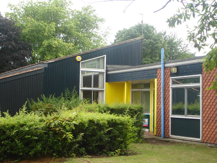
"You could see out beautfully, so that you were part of the outdoor environment - though it was poorly insulated." (Janet Wilson, former teacher, Larkfields Infants) 


Having discoverd that my first school was a 1971/2 CLASP build, (complete with steel frame, timber panels and hung tiles), I decided to pay a visit and venture inside - curbing the CRB madness by using relatives and former neighbours to gain access after school hours.


I was more than aware that that my poor aesthetic heart would be broken by the UPVC and security fencing, so I thought it best to interview my former teacher Janet Wilson for some level headed realities about what it was like to work here. This I hoped, would stop me straying into too much post-war modernist nostalgia and waxing on about Eames, Lyons, the Bauhaus and all the rest of it. Interestingly the conversation revealed more than I had bargend for.


Like me, Janet comes from a local family with a history of Methodism and mining, complete with laissez-faire horror stories passed down to us about times before welfare and compulsary education. To my surprise, the nearby Nuthall Methodist Church built in 1966 had some similar modernist aesthetics and principles to CLASP: it was built on rafts to withstand mining subsidence, it didn't worry about tradition or facing east, but instead focused on what was practical. Coincidentally many of my teachers here were also Methodist, yet this was by no means a religious school.


Both the church and this school were built during the post-war suburban expansion of council houses and private housing into old Nuthall, which had hitherto been an aristocratic parish with very few residents. Thanks to the draconian laws of settlement in the nineteenth century, most of the labouring poor had been squashed up and fighting for survival in either pit village or town slum. Through the centre of Nuthall D. H. Lawrence’s tram car in Tickets Please plunged and jerked on its way from hilly soot stained Eastwood ‘till at last the city looms beyond, the fat gasworks, the narrow factories draw near’.


Today this upper working/lower middle class suburb stunts the growth of the city boundary and is known by the press as marginal voting country or the ‘home of motorway man’: Nottingham for your industrial estate address and the shire for your home.


Both RIBA & the Pevsner guides lament the loss of the unique Temple, which could easily have been a National Trust property if it were not under Junction 26 of the M1. However, the aristocratic decline in the area did allow Basford District Council to become the principle landowner and this allowed Larkfields to became generously endowed with a vast playing field: complete with both running track and football field in an Eric Lyons inspired piece of landscaping. It was so large that all the feeder schools for Kimberley Comprehensive would come here and compete in a district sports day.


The open plan building of Larkfields Infants was centred on play, reflecting the education ethos of the time and making it a malleable place in which to work. However as time progressed the tiles fell, the roof leaked and the fire hazard in the ceiling cavity fanned the flames of concern.


I enjoyed this brief study of my old school but I have to admit that it's taken me nearly a year to pluck up the courage - due simply to the hysteria associated with adults wondering school property. What is also troubling is that the local authority architects of these schools had originally designed these education centres to be accessible to local people of all ages. It is as though schools have now become enclosed spaces: caving into demagogic television and tabloid hysteria. As a former newspaper lad on Coronation Road I know that some of those tardily delivered and rain sodden newspapers are partly to blame.

N. B. This piece of work was commissioned by YH485 Press.

Monday, 20 September 2010

Structure & the City: Station to Art Gallery


The folowing is a visual study of a pedestrian route between a city's train station and contemporary art gallery. How will people visually experience this walk? Some of the abstract terms used are those taken from Christian Leborg's Visual Grammar.

Structure and the City

N.B. The above is just a small experiment as part of my London College of Communication coursework, so I'm not entirely sure what I'm doing here but with any help it may develop into something.

Sunday, 15 August 2010

Nottingham View Points 1: Mapperley Top

Woodthorpe Court and Winchester Court

This is partly in response to Sheffield Publicity Department's recent series of guides to local view points, which are accessible to the public. But it is also in awarenewss that civic vistas play an important role in town planning and a recent local study has correctly identified a few of these in my home town but alas, not all. So I intend to add to the list with my own series of Nottingham View Points and first up is Mapperley Top, where the Keupar Marl Clay lowlands of the Midlands meet the undulating sandstone hills of the North. At 400ft above sea level this is the most elevated part of the city and a painfully steep area which is relieved only by the excellent Bread and Bitter public house. Incidentally, I currently have five complete Castle Rock reward cards squirreled away!


Facing South East
: Towards the Trent

There are hardly any views on Mapperley Top itself and it is only when you begin to descend what is simply a huge ridge, that you are met with an impressive panorama. The two sides of the ridge are different: one faces south east and the alluvial flood plain of the Trent Valley, while the other faces the undulating sandstone hills of Sherwood Forest and the coalfields of the north west.


Porchester Rd, Thorneywood

Looking down the steep Porchester Road you are met with the lush green and blue horizon of the Trent Valley. Notice how the council housing does little to add to this sense of place, though it is perhaps fair to suggest that these buildings certainly appeared more bucolic when they were first built.


Ransom Drive, St Ann's

From here you can see how the city has grown from its original site as the principle crossing point of the Trent. Yet despite this view being sited on land owned by the local authority the view is only accessible via a small grassy knoll. It's also feared that the council may be selling off some of this property for cheap housing development.


Kent Road, Porchester

Here the Keupar Marl contorts into peculiar steep little valleys, which populate the Porchester Estate. Like parts of Hyson Green, this housing estate begun life as a series of allotment plots developed by Nottingham workers and according to Geoffrey Oldfield the shape of some of the plots are still visible, while the streets were named after the original committee members:

The Porchester Estate, with its 800 gardens, subscribed for by instalments paid over 10 years, with the patronage of Ald. Bennett, Sir John Robinson, and Messrs. Whittingham, Haywood, and others, is a valuable institution, showing the power of self-help, of co-operation, of thrift, of the desire to live in quietness with healthy garden surroundings. These gardens were inspected by Lord Salisbury, the prime minister, when in 1889 he on a visit to Nottingham took occasion to announce free education.
(Robert Mellors Historical Articles 1914).


In those days Nottingham was surrounded by allotments, not in their hundreds but in their tens of thousands, and the great Dean Hole…estimated that in his day, about a hundred years ago, there were some 20,000 of them scattered around what was then an important town but not yet a city, and the home of under 200,000 people - an allotment for about every third family.
(Harry Wheatcroft, My life with Roses, 1959)


From Carlton Forum Park you can get a good impression of the hidden valley of the Porchester Estate. To the right of the picture is Mapperley Top and the hospital, while to the left the land slopes towards the Trent. The background and foreground show how the valley dips into a hidden crevice - I think it is safe to guess that this is one of the first of a series of dumbles which mold the clay lands east of the city.


Facing North West
: Towards Sherwood Forest


Sherwood Vale, Sherwood

From this escarpment we are no longer met with a lush valley of clay and alluvium but rather the dark and looming heathland of Sherwood Forest.


Nearby on Morley Avenue (a street name which lured me in for numerous historical reasons) is one of the last remaining Nottingham lace factories originally built out of a clay pit from a nearby brick works. It is important to remember the phrase 'Nottingham was built on Mapperley Hills' and indeed so is St Pancras Station.


Breckhill Park, Woodthorpe Drive

brekka
Old Norse, for 'slope' is fairly common in Lancashire and of very occasional appearance in some other northern counties
(Margaret Gelling, Place-Names in the the Landscape, 1984, p.129)


Woodthorpe Grange Park

One of my favourite parks in the city was given via the varied actions of a string of liberal industrialists which reads like a Who's Who of early twentieth century Nottingham: the eccentric Julien Cahn, Gripper the brick maker, methodist & chemist Jesse Boot, the railway builder Edward Parry and Henry Ashwell J.P., who ran a dyeing company and was an early member of the Thoroton Society. There are many stories of interest here which will have to wait for another time, not least is the Nottingham Suburban Railway, which was again thanks to those civic conscious industrialists. In the distance is Daybrook and the central sandstone watershed of Nottinghamshire.


Woodthrope Grange Park (towards Winchester St)

Woodthorpe and Winchester Court tower blocks overlook the Leen Valley and out towards Sherwood Forest. I think it is safe to assume that these are the same postwar standard 1001/6 Wimpey build as those on Manvers Street in Sneinton; brick walls, concrete panels and square balconies. Neither inspiring nor tasteless, though unlike Sneinton the design is flattered with a rolling public park.


Woodthrope Grange Park

According to the British Association for the Advancement of Science Nottingham is the most geologically complex city in the UK, save for Bristol. Some of this varied topography will be revealed in future views of the eastern clay lands, the Trent Valley, the western coalfields and the sandstone hills of the north, though I may struggle to find a view on the thinly veiled Limestone escarpment. I have previously regurgitated R. M. Butler's Thoroton article on how the modern city's street layout owes much to its geology and medieval field system but this will be a chance to follow a more aesthetic dérive. It is certainly exciting to think that the city has such an interesting topography on which to develop (or grow), though it is perhaps upsetting that it is not always realised.