Tuesday, 17 May 2011

Nottingham to the Sea: Trent Lane Depot

An update:


For an update and petition, please visit this link

Original article as follows:


Trent Lane Depot, Nottingham

Trent Lane Depot was Nottingham's ambitious attempt to connect with the trade of the North Sea during the inter war years of the twentieth century. During that time the Corporation of Nottingham took over management of the Nottingham - Newark stretch of the river. This was when the city was seeking to continue the diversification of its economy, especially since the local monopoly of the lace trade was then clearly at an end. But the corporation was also seeking permission from central government to extend the city boundary from beyond this very location (the eastern end of Sneinton) and eastward into Colwick. Any ambitious project on a national scale was sure to bring the city kudos at a time when it was struggling to shake off a reputation for slums. At first central government refused, on the grounds that the city had yet to clean up its social problems, and so the corporation solicited the help of local architect TC Howitt and begun building a series of 'garden suburbs' of both private and public housing. Nearby council houses off Colwick Road, are witness to this early stage of council house building in Notttingham. It is perhaps no co-incidence that TC Howit's civic centre, which was complete in 1929, was named 'The Council House'. Three years later the boundary was extended.


Corporation of Nottingham c.1930 

The warehouses on Trent Lane were constructed of reinforced concrete and at the time they were proudly considered by the corporation to be among the best in the UK. With a total of 9 floors for loading and discharging materials such as timber, metal, chemicals and manufactured goods. These would be carried by barge to and from Hull, where any international trade could then be transferred onto ships. The 1937 Nottingham handbook proudly states that during the previous year over 230,000 tons had been carried on the Trent and that Nottingham had successfully created a major inland port, boasting "from Nottingham to the sea". Although this is somewhat less than the two or three million tons carried by an international port such as Hull, it is still quite an achievement for a landlocked city.


Second warehouse and dock entrance

In the post war years, petrol was also carried down the Trent to a new depot at Colwick further down stream. It was the growth of the combustion engine coupled with the gradual silting up of the Trent at Stoke Bardolph, which was to bring about the end of Trent Lane by the 1980s. Of recent years there have been attempts to regenerate this area with waterside luxury apartments, although with the onset of the credit crunch, the planned demolition of this site appears to have been put on hold. When I was commissioned to do this walk by Hinterland in 2006, it seemed as though this landscape was going to become another symbol of a laissez-faire era dominated by finance and property. Instead, we are now returning to some traditional ideas set deep with the rotting concrete of Trent Lane: social housing and industry.

--

References:
J. Giggs, Housing, Population and Transport, in J. Becket, (ed.), A Centenary History of Nottingham pp.435 – 462.
Nottingham City Council, The City of Nottingham Official Handbook, (Nottingham, 1937).

Originally written for Hinterland Projects Publication 2 (2009)

Saturday, 7 May 2011

Boston, Holland


Finally, finally got round to writing my own blog post on one of Britain's lessor known towns: Boston, in the Part of Holland, Lincolnshire. This is via Jones the Planner - a collaborative blog between me and the urban designer Adrian Jones. You can also check out our Flickr Sets. Hope you enjoy it.

Saturday, 30 October 2010

CLASP School Open Day


"You could see out beautfully, so that you were part of the outdoor environment - though it was poorly insulated." (Janet Wilson, former teacher, Larkfields Infants) 


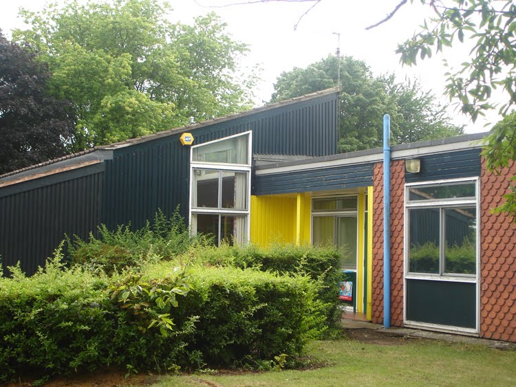
Having discoverd that my first school was a 1971/2 CLASP build, (complete with steel frame, timber panels and hung tiles), I decided to pay a visit and venture inside - curbing the CRB madness by using relatives and former neighbours to gain access after school hours.


I was more than aware that that my poor aesthetic heart would be broken by the UPVC and security fencing, so I thought it best to interview my former teacher Janet Wilson for some level headed realities about what it was like to work here. This I hoped, would stop me straying into too much post-war modernist nostalgia and waxing on about Eames, Lyons, the Bauhaus and all the rest of it. Interestingly the conversation revealed more than I had bargend for.


Like me, Janet comes from a local family with a history of Methodism and mining, complete with laissez-faire horror stories passed down to us about times before welfare and compulsary education. To my surprise, the nearby Nuthall Methodist Church built in 1966 had some similar modernist aesthetics and principles to CLASP: it was built on rafts to withstand mining subsidence, it didn't worry about tradition or facing east, but instead focused on what was practical. Coincidentally many of my teachers here were also Methodist, yet this was by no means a religious school.


Both the church and this school were built during the post-war suburban expansion of council houses and private housing into old Nuthall, which had hitherto been an aristocratic parish with very few residents. Thanks to the draconian laws of settlement in the nineteenth century, most of the labouring poor had been squashed up and fighting for survival in either pit village or town slum. Through the centre of Nuthall D. H. Lawrence’s tram car in Tickets Please plunged and jerked on its way from hilly soot stained Eastwood ‘till at last the city looms beyond, the fat gasworks, the narrow factories draw near’.


Today this upper working/lower middle class suburb stunts the growth of the city boundary and is known by the press as marginal voting country or the ‘home of motorway man’: Nottingham for your industrial estate address and the shire for your home.


Both RIBA & the Pevsner guides lament the loss of the unique Temple, which could easily have been a National Trust property if it were not under Junction 26 of the M1. However, the aristocratic decline in the area did allow Basford District Council to become the principle landowner and this allowed Larkfields to became generously endowed with a vast playing field: complete with both running track and football field in an Eric Lyons inspired piece of landscaping. It was so large that all the feeder schools for Kimberley Comprehensive would come here and compete in a district sports day.


The open plan building of Larkfields Infants was centred on play, reflecting the education ethos of the time and making it a malleable place in which to work. However as time progressed the tiles fell, the roof leaked and the fire hazard in the ceiling cavity fanned the flames of concern.


I enjoyed this brief study of my old school but I have to admit that it's taken me nearly a year to pluck up the courage - due simply to the hysteria associated with adults wondering school property. What is also troubling is that the local authority architects of these schools had originally designed these education centres to be accessible to local people of all ages. It is as though schools have now become enclosed spaces: caving into demagogic television and tabloid hysteria. As a former newspaper lad on Coronation Road I know that some of those tardily delivered and rain sodden newspapers are partly to blame.

N. B. This piece of work was commissioned by YH485 Press.

Monday, 20 September 2010

Structure & the City: Station to Art Gallery


The folowing is a visual study of a pedestrian route between a city's train station and contemporary art gallery. How will people visually experience this walk? Some of the abstract terms used are those taken from Christian Leborg's Visual Grammar.

Structure and the City

N.B. The above is just a small experiment as part of my London College of Communication coursework, so I'm not entirely sure what I'm doing here but with any help it may develop into something.

Sunday, 15 August 2010

Nottingham View Points 1: Mapperley Top

Woodthorpe Court and Winchester Court

This is partly in response to Sheffield Publicity Department's recent series of guides to local view points, which are accessible to the public. But it is also in awarenewss that civic vistas play an important role in town planning and a recent local study has correctly identified a few of these in my home town but alas, not all. So I intend to add to the list with my own series of Nottingham View Points and first up is Mapperley Top, where the Keupar Marl Clay lowlands of the Midlands meet the undulating sandstone hills of the North. At 400ft above sea level this is the most elevated part of the city and a painfully steep area which is relieved only by the excellent Bread and Bitter public house. Incidentally, I currently have five complete Castle Rock reward cards squirreled away!


Facing South East
: Towards the Trent

There are hardly any views on Mapperley Top itself and it is only when you begin to descend what is simply a huge ridge, that you are met with an impressive panorama. The two sides of the ridge are different: one faces south east and the alluvial flood plain of the Trent Valley, while the other faces the undulating sandstone hills of Sherwood Forest and the coalfields of the north west.


Porchester Rd, Thorneywood

Looking down the steep Porchester Road you are met with the lush green and blue horizon of the Trent Valley. Notice how the council housing does little to add to this sense of place, though it is perhaps fair to suggest that these buildings certainly appeared more bucolic when they were first built.


Ransom Drive, St Ann's

From here you can see how the city has grown from its original site as the principle crossing point of the Trent. Yet despite this view being sited on land owned by the local authority the view is only accessible via a small grassy knoll. It's also feared that the council may be selling off some of this property for cheap housing development.


Kent Road, Porchester

Here the Keupar Marl contorts into peculiar steep little valleys, which populate the Porchester Estate. Like parts of Hyson Green, this housing estate begun life as a series of allotment plots developed by Nottingham workers and according to Geoffrey Oldfield the shape of some of the plots are still visible, while the streets were named after the original committee members:

The Porchester Estate, with its 800 gardens, subscribed for by instalments paid over 10 years, with the patronage of Ald. Bennett, Sir John Robinson, and Messrs. Whittingham, Haywood, and others, is a valuable institution, showing the power of self-help, of co-operation, of thrift, of the desire to live in quietness with healthy garden surroundings. These gardens were inspected by Lord Salisbury, the prime minister, when in 1889 he on a visit to Nottingham took occasion to announce free education.
(Robert Mellors Historical Articles 1914).


In those days Nottingham was surrounded by allotments, not in their hundreds but in their tens of thousands, and the great Dean Hole…estimated that in his day, about a hundred years ago, there were some 20,000 of them scattered around what was then an important town but not yet a city, and the home of under 200,000 people - an allotment for about every third family.
(Harry Wheatcroft, My life with Roses, 1959)


From Carlton Forum Park you can get a good impression of the hidden valley of the Porchester Estate. To the right of the picture is Mapperley Top and the hospital, while to the left the land slopes towards the Trent. The background and foreground show how the valley dips into a hidden crevice - I think it is safe to guess that this is one of the first of a series of dumbles which mold the clay lands east of the city.


Facing North West
: Towards Sherwood Forest


Sherwood Vale, Sherwood

From this escarpment we are no longer met with a lush valley of clay and alluvium but rather the dark and looming heathland of Sherwood Forest.


Nearby on Morley Avenue (a street name which lured me in for numerous historical reasons) is one of the last remaining Nottingham lace factories originally built out of a clay pit from a nearby brick works. It is important to remember the phrase 'Nottingham was built on Mapperley Hills' and indeed so is St Pancras Station.


Breckhill Park, Woodthorpe Drive

brekka
Old Norse, for 'slope' is fairly common in Lancashire and of very occasional appearance in some other northern counties
(Margaret Gelling, Place-Names in the the Landscape, 1984, p.129)


Woodthorpe Grange Park

One of my favourite parks in the city was given via the varied actions of a string of liberal industrialists which reads like a Who's Who of early twentieth century Nottingham: the eccentric Julien Cahn, Gripper the brick maker, methodist & chemist Jesse Boot, the railway builder Edward Parry and Henry Ashwell J.P., who ran a dyeing company and was an early member of the Thoroton Society. There are many stories of interest here which will have to wait for another time, not least is the Nottingham Suburban Railway, which was again thanks to those civic conscious industrialists. In the distance is Daybrook and the central sandstone watershed of Nottinghamshire.


Woodthrope Grange Park (towards Winchester St)

Woodthorpe and Winchester Court tower blocks overlook the Leen Valley and out towards Sherwood Forest. I think it is safe to assume that these are the same postwar standard 1001/6 Wimpey build as those on Manvers Street in Sneinton; brick walls, concrete panels and square balconies. Neither inspiring nor tasteless, though unlike Sneinton the design is flattered with a rolling public park.


Woodthrope Grange Park

According to the British Association for the Advancement of Science Nottingham is the most geologically complex city in the UK, save for Bristol. Some of this varied topography will be revealed in future views of the eastern clay lands, the Trent Valley, the western coalfields and the sandstone hills of the north, though I may struggle to find a view on the thinly veiled Limestone escarpment. I have previously regurgitated R. M. Butler's Thoroton article on how the modern city's street layout owes much to its geology and medieval field system but this will be a chance to follow a more aesthetic dérive. It is certainly exciting to think that the city has such an interesting topography on which to develop (or grow), though it is perhaps upsetting that it is not always realised.

Friday, 23 July 2010

River Leen: Cycle and Pedestrian Route


River Leen: Access and Biodiversity Study

This latest town planning study is looking to create a new cycle and pedestrian route along the River Leen and is largely the work of Keith Morgan and the transport planning department at Nottingham City Council. It's basically extending the already successful Big Track idea. I will be creating a historical and visual guide book of sorts and looking for other peoples' responses to the route. Feel free to add your ideas and comments below. Ta.

Saturday, 6 March 2010

Colwick Industrial Estate

This follows part of a group bike ride from Stoke Bardoph Lock to Colwick Industrial Estate, along a newly relayed Trentside path. I have to thank Sneinton Bikers for their patience, as I must have tired then with my insistence on meandering along Sillitoe's tape worm artery of the Trent - stopping at rotting industrial heritage and contemporary manufacturing units.

In 1915 the Corporation of Nottingham took over the entire stretch of river from the city to Newark in an ambitious plan to increase the volume of traffic carried via the Trent. Hitherto the rate of traffic had been in decline; in 1898 the river carried over 400,000 tons per year but by 1915 it had declined below 300,000. By building new locks in the 1920s, such as this one at Stoke Bardolph, and with an extensive river dredging and deepening programme, the corporation successfully doubled tonnage on the Trent to over 650,000 by 1939. But it doesn't end there either, oh no, in 1978 the city had plans to develop the Trent further and build a major European port at Colwick for ocean going ships!

(A. C. Wood, A History of Trade and Transport on the River Trent, in Transactions of the Thoroton Society, 1950, Vo. 54), pp. 1-45.)


Today the river is mainly used for recreation and the 1920s plantation of trees which surround the lock provide an attractive haven for wildlife and a suitable spot for a foraging picnic, which dare I say it in such plain English: is a very nice place! A calming spot to sit and watch an autumn sunset. This can be a positive side of Britain's decline in industrial prowess - good footpaths, nature reserves, public recreation and wildlife. Not luxury riverside apartments inhabited briefly by dodgy football managers - as we shall see further up stream.


Next to the picnic tables is a wildlife guide powered by hand - also notice the bat carving on the corner.


Between the lock and viaduct a cycle path has been relayed alongside the river, which is abutted by Radcliff-on-Trent. No need to explain the Anglo Saxon terminology. Also notice the white bands of gypsum, a feature which rendered the Trent Valley as a centre of medieval alabaster carving, Pale Ale and British Gypsum. Illusive, familiar, moderate, bitter and flowery. It covers the cracks, the faulty joints and the dividing lines.


Unfortunately encased in concrete by British Rail in 1981 but the attempt to strengthen the crossing could have been worse. The bridge was originally built by the Ambergate Railway company - one of those many speculative and imaginative endeavours from the age of steam; this particular fantastical dream was to link Boston with Manchester but didn't get as far as Nottingham. It was eventually bought out by one of oldest of the big six railway companies: The Great Northern, which originated in Stevenson's North East and terminated at King's Cross. But this was Midland Railway country - the fourth of the big six, which originated in The Erewash and terminated at St Pancras. At least private railway competition was real back then, not the botched excuse it is now. Can anyone today seriously imagine each company with their own competing station in every town, or First Great Western sabotaging East Midlands Trains? But this is what happened here, back then in 1852.


By controlling the Grantham to Nottingham line, the Great Northern had a connection to the Erewash coalfields and the MR heartland. The MR retaliated by kidnapping the first GNR locomotive to arrive in Nottingham and it wasn't released for another 7 months following a long winded court case known as the 'battle of Nottingham'. The despute was settled by the GNR agreeing to pay a 10 year lease to the Midland for the use of their property until the they built their own station. It was in lieu of this that the GNR employed one of Nottingham's finest architects in TC Hine to decorate their new line with his then modish Jacobean and Italianate architecture: Nottingham GNR Station, the GNR Warehouse, Aslockton, Bingham, Colwick and Bottesford have the best surviving fragments. Nearby, Netherfield became a Great Northern Railway town with one of the biggest railway sidings in Midland country but was largely disbanded since post war nationalisation. This is one of those moments where Ray Gosling's observation about Nottingham can ring true, as a place 'where the Midlands meets the North'. Though I don't know if it is always a friendly meeting but sometimes more of an actual tension. The line also splits in two here - with another concrete viaduct which until 1993 was a mineral line to Cotgrave Colliery.

At evening by the lights of Netherfield-Dubovka
Walk similar embankments and announce their love

To rivers snaking over peacetime faces.

Alan Sillitoe A falling out of love and other poems (1964)


The Clayton Shuttleworth & Co. is credited with manufacturing the ironwork for this bridge - a Lincolnshire engineering company which made various machines for agriculture; threshing, ploughs, portable steam engines and so on. It is understandable why this company had a clear interest in the Ambergate Railway - connecting the Lincolnshire farmlands with the north midland coalfields. Boosted with the sales from the Great Exhibition, by 1857 the company was described as having machines all over the Austro-Hungarian Empire, with factories in both Vienna and Budapest. Despite the overwhelming success of the 1850s, by the turn of the century British agricultural machinery had lost out to American developments in reaping and binding technology. The post 1870 agricultural depression hadn't helped either when British farmers struggled amid growing international competition. There is a common tension thoughout these tales of British rise and decline; at one end proud complacency and at the other increasing international growth.

(The Market and the Development of the Mechanical Engineering Industries in Britain, 1860-1914, by S. B. Saul © 1967 Economic History Society.)


Cycling east to west, Park Logistics is one of the first firms you encounter at Colwick Industrial Estate.


One of the other major sites is Wastecycle, a private refuse collection and recycling company.


Trent Concrete has been here since 1919 and is one of the largest prefabricated concrete businesses in the United Kingdom, with a staff of nearly 150 people. Its most significant project of recent years has been the precast concrete panels for Nottingham Contemporary using technology developed at Derby University. Historically the company has been an essential part of twentieth century construction in Britain, taking it's raw material from the numerous gravel terraces of the Trent Vallery. From the 1920s to the 50s Trent Concrete provided the material for "Nottingham's Highway to the Sea", and ambitious infrastructure project along the river which included warehouses, locks, sluices and dredging work.


Armitage Brothers has a Royal Warrant for the manufacture and supply of pet food, priding itself on being the largest companies of its kind in Europe. It is over 200 years old and has had its main factory and distribution centre based in Colwick since the conception of the industrial estate during the interwar period. The writer Wayne Burrows worked here for a short time until he moved on to better things at the McCain Chip factory in Grantham.


The estate was originally conceived as an inland port to Hull and eventually the North Sea. It was generally considered a success by the 1960s but twenty years later this function had declined due to a combination of reasons, some of which include: the silting up of the Trent at Stoke Bardloph, an increase in road traffic and I think also the piping of north sea oil to Colwick - though as yet I can find no further information about the inland piping of refined oil.


Access to water traffic was a valuable asset for the import of raw sugar. Perhaps the oldest building on the estate is the Sugar Beet Factory - an industry which was established in England between 1912 and 1928 and one which was more predominant in the flat lands of East Anglia. Colwick was therefore of marginal importance in the industry, being developed out of speculative corporate decisions rather than locational necessity. There were and still are a small number of sugar beet factories in the UK, although Colwick is no longer one of them. This was an industry which appears to have developed out of Britain's decline in its international standing: in the nineteenth century it had relied on imports via empire and the continental dumping of sugar - hence the Victorian origins of Tate & Lyle. All this changed in the early years of the twentieth century when the dumping of sugar in Europe was restricted by international agreement and new customs duties were imposed on the material. The site is now used by Kitchen World and the grounds as depot for Leec - manufactures of medical and mortuary equipment.

(The Location of the Beet-Sugar Industry in England and Wales, 1912-36, by H. D. Watts © 1971 The Royal Geographical Society (with the Institute of British Geographers).)


Since the dredging of the River in the 1920s, this was a place where oil could be distributed from Hull via the Trent to the petroleum depot at Colwick - an important distrubution centre for the East Midlands. The oil drums are still an impressive site from the Colwick Loop Road, but it is now a shadow of its former self - at one time the site was home to Texaco, Esso and Total but it appears that only the latter remains - the adjacent site of the former occupants have been cleared for redevelopment.
(The Inland Waterways of the United Kingdom in the 1960s Author(s): H. D. Watts Source: Economic Geography, Vol. 43, No. 4 (Oct., 1967), pp. 303-313)


ROL is an international retail fixture suppliers which has offices in Italy, Denmark, Sweeden, Holland, Spain, France, Brazil, USA and Thailand. It is not suprising that its UK headquaters are based here given the city's history in commerical manufacture - especially Boots. World-wide ROL employs over 500 people.


It is perhaps fair to suggest that the quality of architecture at Colwick has declined since the 1970s and this building marks the last attempt at industrial aesthetics, in this case a muted Scandinavian modernism. Manufacturing is still a vital part of the economy, but its relative neglect compared to finance and business is evident in nearly every industrial estate I have been to in Nottingham. Business Parks at Ruddington, Pheonix Park, NG2 and Assarts Farm have pine plantations, good roads and new builds - many of which are empty. Yet manufacturing estates such as Glaisdale Drive, Lenton, Bulwell, Dunkirk, Radford, Stapleford, Basford and Eastwood are left to rot; with huge potholes and a regular diet of dodgy burger vans. This is the unit which my Dad rents for engineering here. Bio City and the Science Park are notable exceptions, though they are not built for mechanical engineers or manufacturers.


Notice the potholes. In 1907 textiles was the largest single branch of engineering in the UK and a dominant force in world trade. Earnest Jardine was one of its major players with a highly successfuly lace machine making company based in Nottingham. Colwick Industrial Estate was originally conceived in the 1920s and financed by Jardine's ambitious plans to make way for the city's expansion and make money in industrial real estate. It is perhaps testament to his forward planning that some of the original occupants are still here, though it is also a little endemic of the lace machine markers' complacency that companies such as Jardines are no longer with us. But all this is sometimes just provincial English self depreciation, which hides the fact that since the 1980s, central government has often done little to help industry in the regions. Since the spectacular crash of the finance and property driven economy in 2008, we are supposedly seeing a return of industrial interventionism by government. I will believe it when I see it on the banks of the Trent.


Candle Meadow estate with the hill of Bakersfield in the distance in an Eric Lyons style prefabricated modernism, though without the same middle class wealth or sensitivity to landscape. This could have perhaps had a better relation to lakes of Colwick Park but instead they are enclosed by the busy Colwick Road on one side and flood embankments on the other. Having said all that they do have a fair bit of public green space in the back alleys - which provides a separate pedestrian walkway from the road.


Finally our tour ends at Trent Lane, immediately adjacent Trent Lane Depot. An interesting location which juxtaposes working class entertainment with a failed residential development designed for the super rich. Though River Crescent does have some (sort of) environmental credentials (taking heat from the Trent to heat the swimming pool), the bulking mass of this development is an aggressive affront to riverside. Its size was rightly criticised by residents at Lady Bay, and so far the very few City bankers  have found a home here. Sven Goren Erkison took a flat for a short while - a neat analogy as his whole premise for being here was based on financial scam at poor Notts County. Currently the scheme looks as though it is heading towards receivership. Neighboring this Trent River Cruises continues to patrol the Trent, where revelers and boatmen discuss the forgotten history of the riverside.